“Check out the latest travel trends in Korea on StepToKorea!”
Seonginbong Primeval Forest
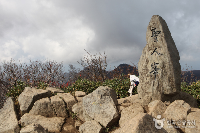
Seonginbong Primeval Forest (Natural Monument) is the only flatland located on Ulleungdo Island, with a diameter of about 2km. At the end of past volcanic activity, magma from underground emerged to the surface, creating underground voids that collapsed under the weight of the ground, forming a deeply concave basin-like terrain. This turned into a caldera lake with water pooling in. Over time, sediment from the surrounding area flowed into the lake, accumulated, and drained out, forming the current flat land. Seonginbong Primeval Forest has been untouched by human interference for a long time, allowing rare plants to thrive abundantly here.
• Address (location): Namyang-ri, Seomyeon, Ulleung-gun, Gyeongsangbuk-do
Songgotbong
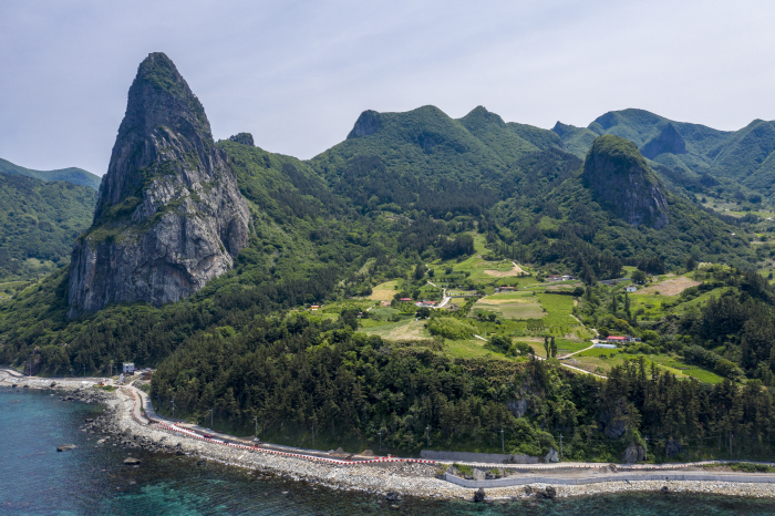
Songgotbong is a large cliff with an elevation of 430m, created from solidified lava flows, just like Noeunbong. Its sharp peak resembles an arrow, hence the name Songgotbong, which means ‘arrow peak’ in Korean. The relatively high-viscosity basalt rock easily formed a volcanic dome by pushing up on the surface. Over time, erosion wore away the upper part of the volcanic dome and surrounding rocks, resulting in the steep and pointed shape we see today. At the back, there are 8 holes believed to have been drilled by the Jade Emperor to lift up good people who have not committed sins to heaven, created through selective erosion.
• Address (location): 21-1 Nari Mountain, Book-myeon, Ulleung County, Gyeongsangbuk-do
Dodong Coastal Walking Trail
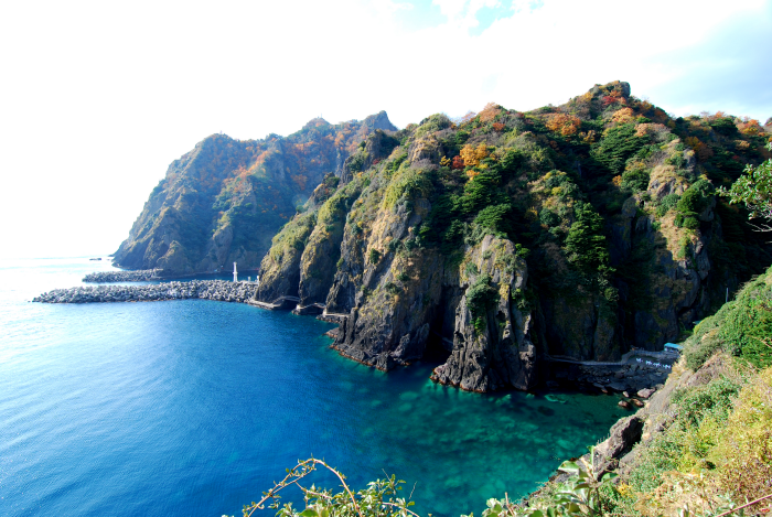
Dodong Coastal Walking Trail is connected to Jeodong Coastal Walking Trail, collectively known as Haengnam Coastal Walking Trail, specifically referring to the 1st section of Ulleung Haedamgil, Haengnam Coastal Road (2.8km), recognized as Coastal Enjoyment Trail Course 34. This trail is popular among tourists due to its well-maintained facilities such as a rainbow bridge and LED streetlights with geological park logos, providing excellent accessibility.
Dodong Coastal Walking Trail showcases various geological structures preserving the characteristics of early volcanic activity on Ulleungdo Island. As you walk from Dodong Port to Dodong Lighthouse, you can observe a trend of relatively younger rock formations. The trail features a sequence of rock types including re-deposited tuffaceous breccia formed by the transportation of volcanic rock fragments by landslides, ignimbrite created from volcanic ash deposited in a hot state, and tuffaceous breccia, a type of extrusive rock, distributed in order.
• Address (location): Dodong-ri, Ulleung-eup, Ulleung County, Gyeongsangbuk-do
“Check out a variety of travel itineraries at a glance on StepToKorea!”
East Sea Coast Trail
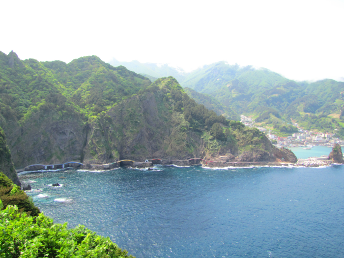
The Jeodong Coastal Walkway connects with the Dodong Coastal Walkway, collectively known as the Haengnam Coastal Walkway. Formed during the early volcanic activity on Ulleungdo Island, the walkway features volcanic rocks primarily composed of basalt. Visitors can admire various geological features such as pillow lava, clinkers, coastal waterfalls, sea caves, joints and faults, and dikes. Particularly fascinating is the pillow lava seen here, resembling pillows with its rounded and elongated shapes, formed as lava erupted underwater, creating a toothpaste-squeezed appearance. (Source: Ulleungdo and Dokdo Geopark)
• Address (location): Dodong-ri, Ulleung-eup, Ulleung-gun, Gyeongsangbuk-do
Taeha Coastal Walking Trail and Daepunggam
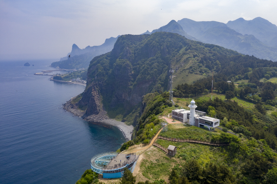
The Taeha Coastal Walking Trail offers a charming journey up a bridge next to a clay cave, adorned with stories and photo zones of Taeha Village on the bridge walls. The trail boasts stunning coastal scenery featuring unique erosion patterns by the sea breeze, formed by majestic rock formations like Jomyeonam and Jipgoeam. Particularly fascinating are the ‘tafoni’ formations, honeycomb-like holes created through chemical weathering as salt carried by the sea breeze seeps into rock crevices.
Taking a leisurely 6-minute ride on the Taeha Hyangmok Monorail and a 20-minute walk along the trail leads to the Ulleungdo Lighthouse (Taeha Lighthouse) and the Hyangmok Geological Skywalk. The northern coastal view from the skywalk has been recognized as one of Korea’s top 10 scenic wonders by the monthly magazine ‘Mountain.’ The fragrant wood trees (Hyangmok) thriving in the strong winds have adapted to a unique ecology, growing roots in the minimal soil eroded between rocks, isolated from the mainland for a long time, leading to their designation as natural monuments for their high value.
• Address (location): Taeha-ri, Seo-myeon, Ulleung County, Gyeongsangbuk-do
Dodong Mineral Spring Park
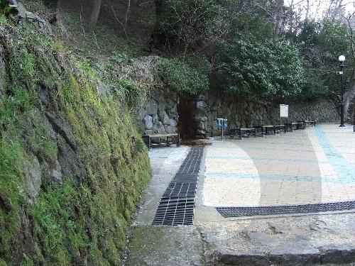
Dodong Mineral Spring Park is located 300m away from Dodong Port, the gateway to Ulleung-gun, Gyeongsangbuk-do. It was established to provide a peaceful retreat for locals and offer various attractions for tourists visiting the island. Legend has it that a general, who fought against Japanese invaders, buried his armor near Dodong Mineral Spring after perishing in battle. The water that flowed from the rusted armor became Dodong Mineral Spring.
Dodong Mineral Spring Park features Dodong Mineral Spring, a Folklore Gallery, Dokdo Museum, Dokdo Observatory Cable Car, Ahn Yong-bok Memorial, Artificial Rock Climbing Wall, Kim Ha-woo’s Songdeokbi Stele, a Viewing Square, Sports Facilities, and tourist amenities such as rest areas, snack shops, meeting rooms, platforms, and a gift corner.
• Address (location): Dodong-ri, Ulleung-eup, Ulleung-gun, Gyeongsangbuk-do
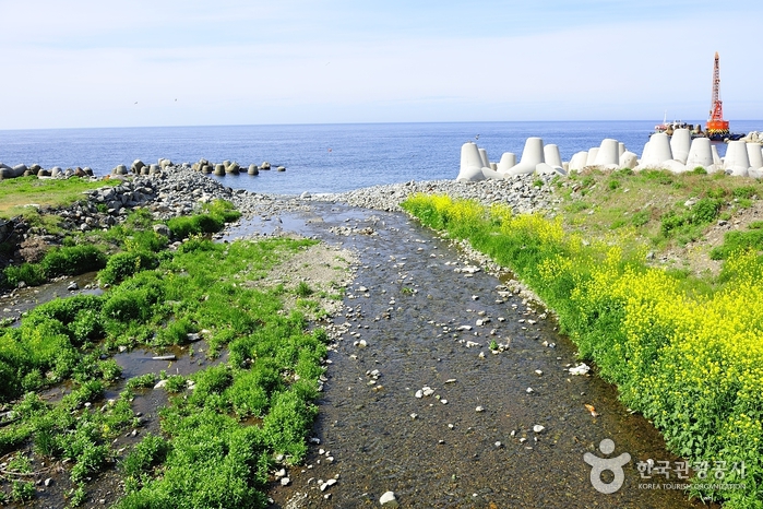
Yongchulso
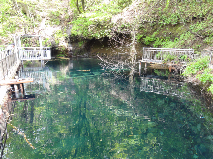
After the volcano was submerged and a caldera lake was formed, porous rocks with high permeability were deposited in the lake, serving as an underground water reservoir. As the infiltrated groundwater moves along the high-permeability rock deposit layer, it encounters impermeable layers (basalt) on the outskirts of the Nari Basin, causing it to rise to the surface and form a spring.
The spring corresponds to a natural spring where groundwater naturally emerges to the surface, with a flow rate reaching 20,000 tons per day. The water temperature remains relatively constant throughout the year, belonging to the low-temperature groundwater category with an average of 10.2℃. The pH level ranges from 8.1 to 8.3, slightly alkaline, and the dissolved oxygen (DO) level is between 7.2 to 9.4mg/L. The water quality type is alkaline bicarbonate (Na, K-HCO₃).
• Address (location): Na-ri, Buk-myeon, Ulleung-gun, Gyeongsangbuk-do
“If you’re curious about the itineraries of travel experts, StepToKorea!”
Samseonam
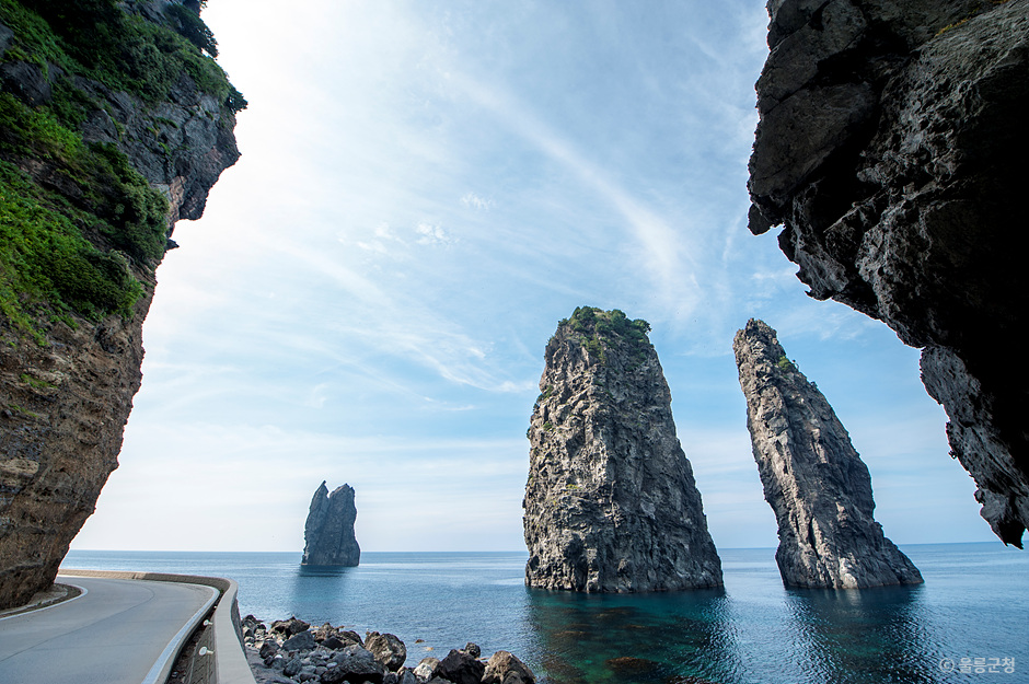
Samseonam is a place on Ulleungdo Island known for its stunning marine landscape, consisting of Ilseonam, Iseonam, and Samseonam. Samseonam features developed columnar jointing, formed by the action of waves causing pillars to stack up, with distinctive honeycomb-like holes created by weathering on the surface, known as tafoni. Legend has it that three celestial maidens captivated by Ulleungdo Island’s exceptional beauty missed their chance to return to the sky, incurring the wrath of the Jade Emperor and turning into rocks here. Particularly, the youngest maiden, known for her stubbornness, transformed into Ilseonam where not even grass grows.
• Address (location): Gyeongsangbuk-do, Ulleung-gun, Buk-myeon, Cheonbu-ri
Hakpo Coastal Area
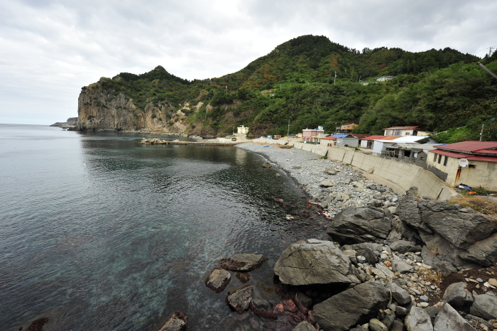
Hakpo is known for its beautiful coastal scenery and historical ruins related to the exploration of Ulleungdo Island. Along the Hakpo coast, you can find rock formations like Jibgoeam, Eunhoeeam, and Jomyeonam. The sturdy Jomyeonam rocks resist erosion from the waves, forming cliffs that jut out into the sea. On the other hand, Jibgoeam and Eunhoeeam are more vulnerable to weathering and erosion, creating coves that indent into the beach. The Hakpo coast also features sea cliffs, where the lower parts erode vertically, leading to collapses due to gravity, resulting in steep cliffs. Visitors can fully enjoy the charm of Hakpo by staying at the nearby Hakpo Camping Site.
• Address (location): 166-29 Hakpo-gil, Seo-myeon, Ulleung-gun, Gyeongsangbuk-do
Naesujeon Pebble Beach
Naesujeon Mongdol Beach is located in Jeodong-ri on Ulleungdo Island. Originally known as Jeojeonpo due to the abundance of alder trees, it was later named Naesujeon after Kim Naesu, a pioneer on Ulleungdo Island who lived here and cultivated the area. This small beach, made up of smooth pebbles, is known for its crystal-clear waters, making it a popular spot for snorkeling. Families can enjoy a relaxing time together with the added convenience of a swimming pool and shower facilities for safe swimming. Nearby, you can also visit Naesujeon Mineral Spring and Naesujeon Sunrise Observatory, where you can admire the breathtaking scenery of Ulleungdo Island.
• Address (location): Jeodong-ri, Ulleung-eup, Ulleung-gun, Gyeongsangbuk-do
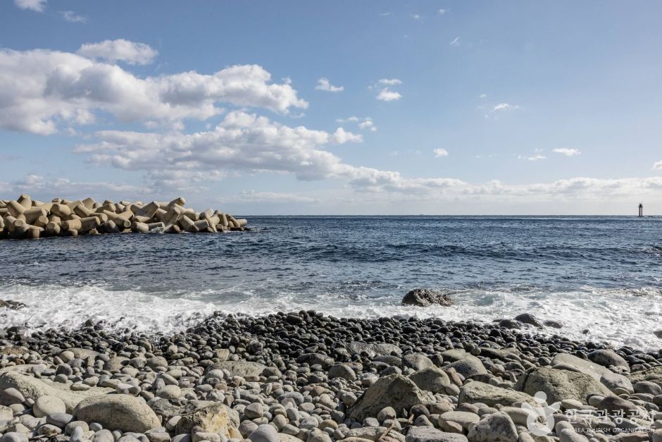
Tonggumi Pebble Beach
Called ‘Tonggumi’ because the village looks like a tunnel with deep, narrow valleys on either side and rocks shaped like turtles crawling towards the village, Tonggumi is the only natural harbor in Ulleung-gun. Facing the village is Turtle Rock, a rock formation resembling a turtle, standing in the sea in front of Tonggumi. Connecting Turtle Rock and the coastal cliffs is Tonggumi Pebble Beach, a 1km long beach filled with natural pebbles. Between the village and the sea, ancient pine and fir trees such as thousand-year-old pine trees and Japanese red pines are preserved in their original form. Tonggumi Pebble Beach, located next to the coastal road encircling Ulleungdo Island, offers well-maintained accommodation and facilities for enjoying marine sports such as swimming and diving.
• Address (location): Ulleung-sunhwan-ro, Seo-myeon, Ulleung-gun, Gyeongsangbuk-do
Dokdo
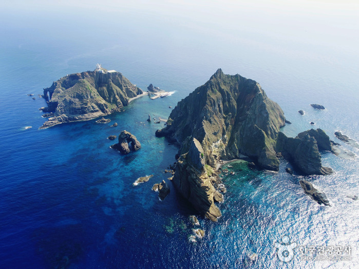
Dokdo, the easternmost island in our country, is located at 131 degrees 52 minutes east longitude and 37 degrees 14 minutes north latitude for Dongdo, and 131 degrees 51 minutes east longitude and 37 degrees 14 minutes north latitude for Seodo. It is a volcanic island consisting of two relatively large islands and small rocky islets. Rare seabirds such as storm petrels and black-tailed gulls inhabit the area, designated and protected as a natural monument. The clear waters of the East Sea, the solitary island, and the diverse seaweeds create a breathtakingly beautiful sight.
Dokdo, designated as a natural monument (named Dokdo Natural Protected Area), had restricted public access based on Article 33 of the Cultural Heritage Protection Act. However, in line with a government policy change on March 24, 2005, the restriction on public access to Dongdo, one of the restricted areas, was lifted. The permit system was also changed from entry permits to simple reporting, and the previous daily limit of 1,880 visitors was abolished in June 2009.
Dongdo, located in the southeast, stands at a height of 98.6m with a circumference of 2.8km and an area of 73,297㎡. It houses most of the marine and fishery facilities, including the lighthouse, and features a Dongdo pier spanning 1,945㎡ (588 pyeong), capable of accommodating ships up to 500 tons, welcoming tourists visiting Dokdo every day. Moreover, with rainwater and freshwater facilities in place, it produces around 1,500 liters of drinking water daily, showcasing itself as an essential life source for the people of South Korea.
Seodo, located in the northwest, rises to a height of 168.5m with a circumference of 2.6km and an area of 88,740㎡, forming a rugged conical peak. It currently serves as a shelter for fishermen in emergencies. Additionally, the area of the subsidiary islets is 25,517㎡, featuring variously shaped islets like Gajae Rock, Doklipmun Rock, Chotdae Rock, and Eolgul Rock. The surrounding waters of Dokdo, a clean fishing ground where the warm and cold currents meet, form coastal and deep-sea fishing grounds, creating a golden fishing zone.
• Address (location): 55 Dokdo Isabu-gil, Ulleung-eup, Ulleung-gun, Gyeongsangbuk-do
Three Brothers Cave Rock
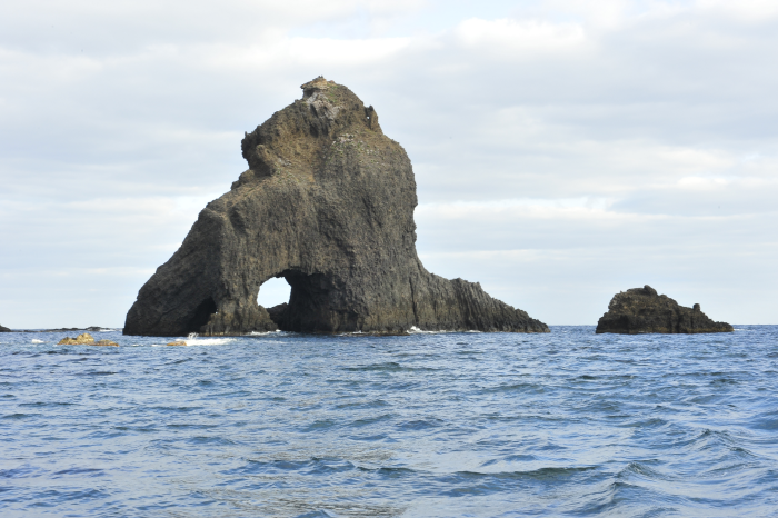
Located between Dokdo Island and Ulleungdo Island, there are three rocky islets that act as a connecting bridge, forming part of the Dokdo National Geopark. One of these islets, situated in the northeast of Ulleungdo Island, stands at a height of 44 meters and is known as the Samhyeongje Gulbawi, named for its three distinct sea caves meeting at a single point. The lower part is composed of well-developed columnar jointed Andesite, while the upper part consists of tuffaceous rocks. The waves crashing in from the open sea are so high that they completely cover Samhyeongje Gulbawi, creating an environment where plant life cannot thrive due to the high salt content.
• Address (location): Dokdo-ri, Ulleung-eup, Ulleung-gun, Gyeongsangbuk-do
Jukdo
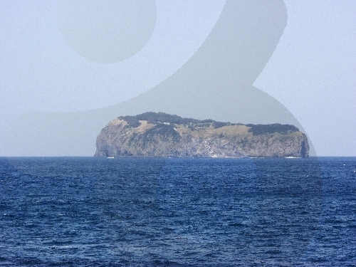
Jukdo is an island located in the sea 4km northeast of Jeodong Port in Ulleungdo Island, the largest among the affiliated islands of Ulleungdo Island. Originally connected to Ulleungdo Island, Jukdo became a separate geological site over time due to erosion by waves. During the early days of exploration, Jukdo was abundant in bamboo, hence it is also known as Daeseom or Bamboo Island.
Accessible by a 15-minute ferry ride from Dodong Port, Jukdo offers a trekking course that allows visitors to explore the entire island by climbing 365 spiral stairs at Jukdo Port. Starting from Hwanyeongwon, the trekking course takes about 1 hour and 30 minutes to complete, passing through the Observation Rest Area, Memorial Garden, Garden of Wind, and outdoor stage before returning to the starting point.
• Address (location): 59-9 Jukdo-gil, Ulleung-eup, Ulleung-gun, Gyeongsangbuk-do