Mt. Bibong
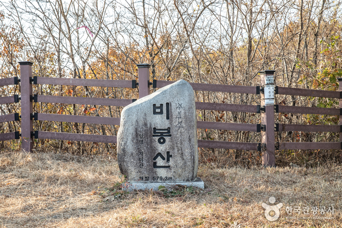
Mt. Bibong, also known as Jamsan, is a famous mountain in Korea. Before the Goryeo Dynasty, it was called Taehaengsan or Daehangsan. When viewed from the east, Mt. Bibong resembles a bird spreading its wings and sitting down, while from the south, it looks like a general wearing a helmet standing tall. From the north, it appears as a brave general in a commanding posture, facing Oknyeobong.
The Nakdong River, like white silk, flows beneath the northern slope, forming the boundary with Yecheon County. Surrounding the mountain are vast plains and prominent peaks such as Hakkasan, Palgongsan, Bohyeonsan, Gapjangsan, Noaksan, and Sokrisan, which can be seen at a glance.
• Address (location): Bongjeong-ri, Dain-myeon, Uiseong-gun, Gyeongsangbuk-do
The Eco-Village of Uiseong’s Whydah Crane
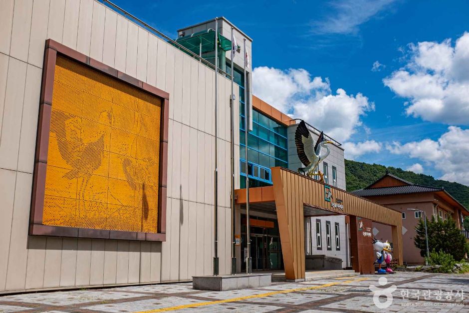
The Uiseong Egret Eco-Village was created to preserve and manage the natural ecosystem for the coexistence of nature and people. Uiseong Cheonghak Village has been home to egrets (cheonghak) and herons (baekhak) since the early 1900s, making it the largest egret habitat in Korea.
This village has been developed as a tourist destination where visitors can experience ecology away from residential areas. There is also an Egret Eco Center, a beneficial space where you can not only see egrets but also observe various other bird species and gain information about the ecosystem.
• Address (location): “1185 Waegari-gil, Sinpyeong-myeon, Uiseong-gun, Gyeongsangbuk-do”
Geumbong Nature Recreation Forest
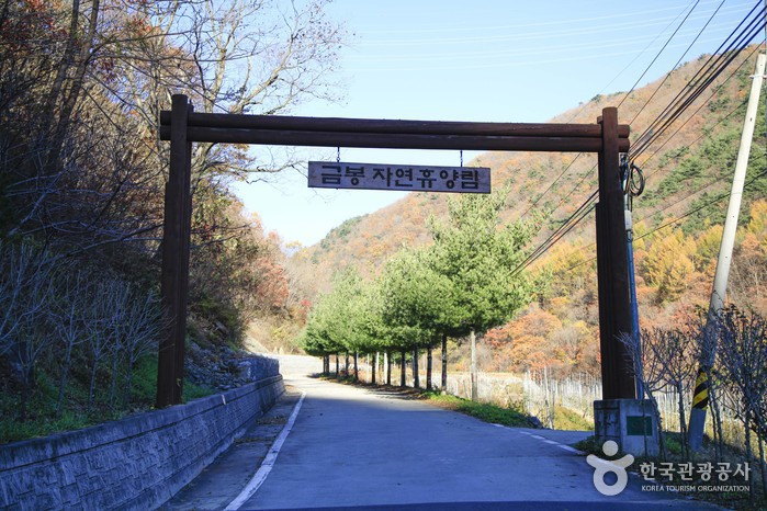
Geumbong Nature Resort is a tranquil natural retreat located in Oksan-myeon. Established by Uiseong County in 2004, the resort includes a forest leisure center, a multipurpose training center, forest cabins, log cabins, experiential areas, campfire pits, showers, and cooking facilities.
The multipurpose training center is equipped with seminar rooms, meeting halls, and a small performance venue, making it suitable for group events. The log cabins are nestled among various trees such as oak, pine, maple, and zelkova, offering guests a chance to relax in the natural scents of the forest.
One of the popular experiential programs is the Forest Path Experience, where you can walk along a healing forest path with a guide and encounter arrowwood, lady’s slipper orchids, and water fringe trees.
• Address (location): 114, Gumbong Nature Recreation Forest, Huyangnim-gil, Uiseong-gun, Gyeongsangbuk-do
“Plan your perfect trip with StepToKorea! Explore the cultural charms of various cities in Korea.”
Binggye Valley
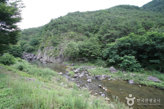
Located in Seowon Village, Binggye 3-ri, Binggye Valley is one of the eight scenic spots in Gyeongbuk Palgye (Eight Scenic Views of Gyeongsangbuk-do). Designated as a county park on September 25, 1987, this gorge is famous for its mystical beauty.
With ice holes and wind holes creating an icy mountain, the flowing water is called Binggye, and the nearby village is named Binggye-ri. Binggye Valley features cool waters running through cliffs, with eight famous spots to explore. From the entrance, visitors can see Yongchu, Mulle Banga, Wind Hole, Eojinbawi, Uigak, and Sutab.
Among them, Yongchu is a deep pool under a cliff, believed to be where a dragon’s head fought with a Buddha. Eojinbawi Inam is a large rock standing more than 2.4 meters high and 1.2 meters wide. When the sun hits the rock at noon, a human face-shaped shadow appears, giving a mystical sense of guidance.
• Address (location): Chunsan-myeon, Uiseong-gun, Gyeongsangbuk-do
Eiseong Jeongok Valley
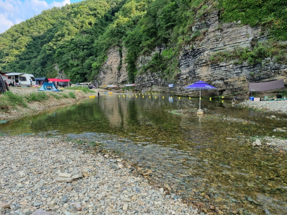
Jeongok Valley is a popular summer destination among locals. Visitors can enjoy both water activities and camping. The valley features a scenic stream flowing past rocky cliffs and offers a spacious camping ground.
Signs clearly indicate the Tent-Only Zone at Sajon 1 and the RV-Only Zone at Sajon 2. The water is shallow and ideal for swimming, though visitors should still be cautious of deeper areas.
• Address (location): 667-1 Sacheon-ri, Jeongok-myeon, Uiseong-gun, Gyeongsangbuk-do
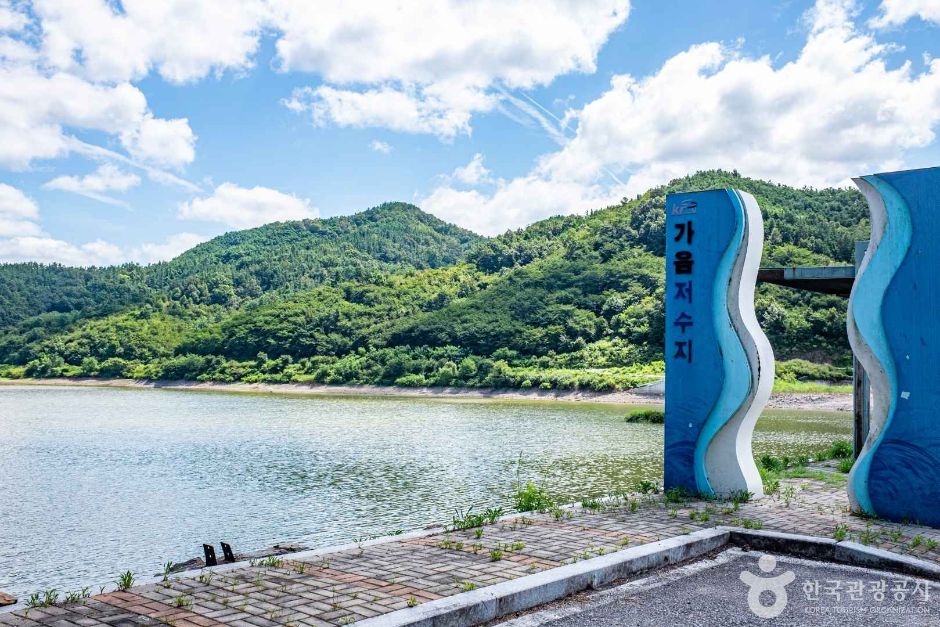
Gaecheonji
Located in Bongyang-ri, Angye-myeon, Gaecheonji is a reservoir with a long history, first recorded in 1530 in the Dongguk Yeoji Seungnam. Covering 59.2 hectares and holding about 3,600 tons of water, this reservoir is situated 1 km southeast of Angye-myeon.
Gaecheonji is known for its freshwater fish such as crucian carp, carp, and trout, attracting many fishing enthusiasts. The area is lined with cherry blossom roads and offers a stunning natural environment, particularly under the scenic backdrop of Bongsung Mountain.
A second reservoir was built in Gucheon-myeon between 1952 and 1959, becoming the largest in the province at the time. Despite the relocation of over 40 households, the strategic location and picturesque lake surrounded by mountains make this a special place. The area is designated a no-fishing zone to protect aquatic life.
• Address (location): Iwon, Angye-myeon, Uiseong-gun, Gyeongsangbuk-do
Gaemji Reservoir
Gaemji in Uiseong is famous for its tranquil waters and abundant fish species such as carp, crucian carp, catfish, pond loach, and bullhead. Unlike most reservoirs in Korea, fishing is allowed here to promote tourism and the local economy.
The peaceful waters and scenic countryside landscape attract both local and visiting fishing enthusiasts. It’s also a favorite spot for drives and walks.
• Address (location): Deokbong-ri, Sinpyeong-myeon, Uiseong-gun, Gyeongsangbuk-do
“Discover hidden travel destinations in every nook and cranny of Korea with StepToKorea!”
Uiseong Sacheon-ri Horizontal Forest
In the village of Sajon, there is a natural monument called the Sajon-ri Horizontal Forest. It was established by Kim Ja-cheom, a member of the Andong Kim clan, to block the winds from the west and protect the village’s prosperity.
Known as Seorim, this windbreak forest features trees like pine, oak, and chestnut. Planted when the village was established, the forest has now grown for over 600 years, forming a path approximately 1 km long and 45 meters wide.
• Address (location): 17 Jeongok-gil, Jeongok-myeon, Uiseong-gun, Gyeongsangbuk-do, South Korea
Jeosori Dinosaur Footprint Fossil Site
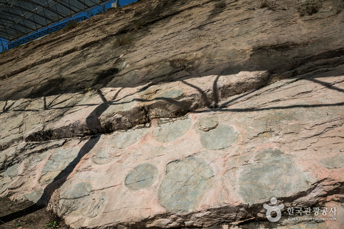
The Jeosori Fossil Site contains dinosaur footprints from the Cretaceous period, about 115 million years ago. Designated as a natural monument on June 1, 1993, the site features 316 footprints from four types of dinosaurs, including herbivores like Ultrasaurus and ankylosaurs, and the carnivorous Koreanosaurus.
Discovered during the construction of a military training ground, these footprints reveal valuable insights into the behavior and diversity of prehistoric life in Korea.
• Address (location): 179-18 Gongnyong-ro, Geumseong-myeon, Uiseong-gun, Gyeongsangbuk-do
Uiseong Sogoddang
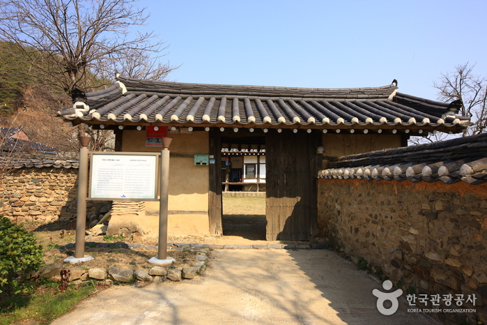
Sogedang, located in Yoonam-ri, Jeongok-myeon, was built around 1800 by Nam Jeong-gi of the Nam family during the Joseon Dynasty. The complex includes a main building, a detached house, and a connecting structure.
Upon entering the main gate, visitors will see a spacious courtyard, a U-shaped detached house facing south, and an L-shaped main building. The detached house features a porch and a beautiful partition, while the main building includes a central hall, bedrooms, and a kitchen.
In front of the complex stands a 400-year-old king’s willow tree. The Nam family, originally from Yeongyang, has left behind several architectural heritage sites in the village, including Uiseong Iggedang and Uiseong Seogedang.
• Address (location): 1034 Uiseong-gil-an Road, Jeongok-myeon, Uiseong-gun, Gyeongsangbuk-do
Sanun Village
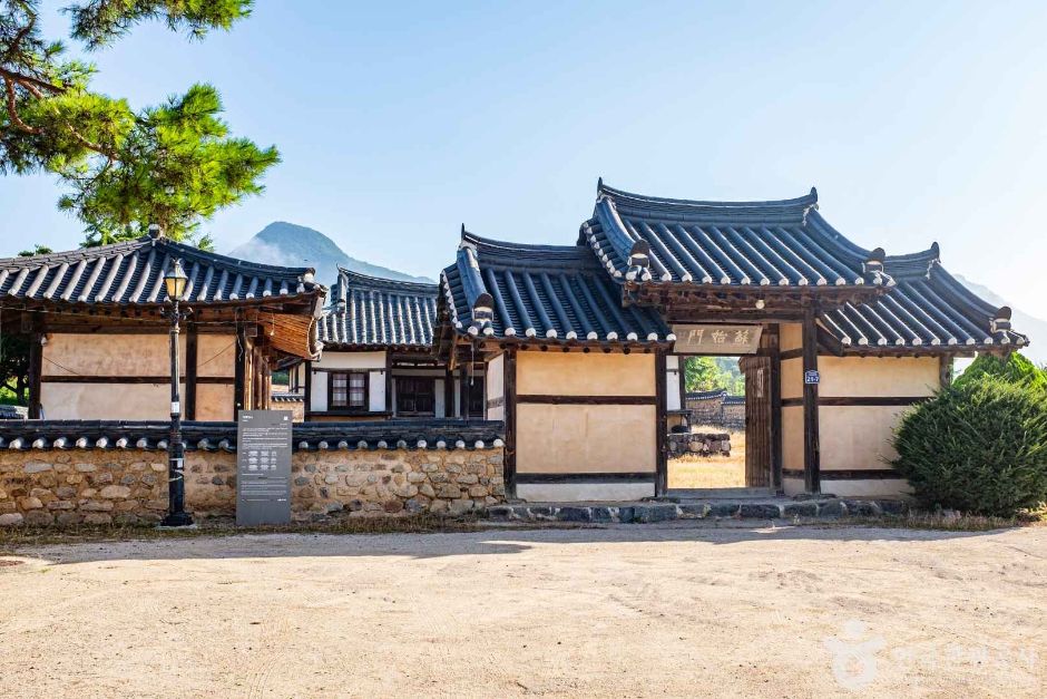
Sanun Village, also known as Daegam Village, is a traditional rural village of the Yeongcheon Lee family. Nestled between Mt. Geumseong and Mt. Bibong, the village is set among scenic hills and plains filled with legends.
Along the valley of Mt. Geumseong lies a reservoir and rice paddies. To the south flows the Ssanggyecheon stream, nourishing the farmland. The village’s geography resembles the poetic image of a fairy combing her hair before a mirror.
The name Sanun, meaning “mountain clouds,” dates back to the Silla Dynasty. During the Joseon Dynasty, influential scholars and officials like Lee Kwang-jun and Yi Hee-bal settled here. The village features traditional houses and cultural heritage sites such as Hakrok Jeongsa, Ungokdang, Soudang, and Jeonoudang, where visitors can experience authentic hanok living and explore an ecological park.
• Address (location): 19 Suseongsa-gil, Geumseong-myeon, Uiseong-gun, Gyeongsangbuk-do